Monitoring Tropical Storm Sinlaku
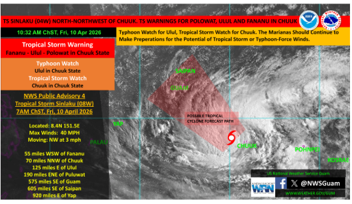
As of this morning, the storm is north of Chuuk with sustained winds around 40 mph and moving slowly northwest. Current forecasts show a potential track toward the Marianas, though there is still some uncertainty in how far north or south it may shift over the next day. For now, conditions in the Marianas remain relatively stable, but that is expected to change heading into late Sunday, with winds and weather deteriorating into early next week. The current outlook suggests the possibility of tropical storm force winds arriving around Monday, with impacts extending across the Marianas. Being prepared is never a waste of time. Check in on your neighbors and think of what you need to do to begin preparing now, especially for strong winds and rough seas. While the exact track is still being refined, the window for preparation is already here. My office will continue to stay in close contact with local and federal partners and will share updates as conditions develop.